Having a good, readable map of your trail will greatly enhance your visitors’ experience.
Scale and Accuracy - The map does not have to be exactly topographically accurate (though state that on the map so users know). However, it is good to get distances in relative scale. This way trail users can see the overall layout and plan where they want to go with the time they have. If the trail is a circle or a “there and back” affects the trail user’s plan and should be known ahead of time. If there are small branches off the main route of the trail with sites of interest they will get more visitors if they are on the map.
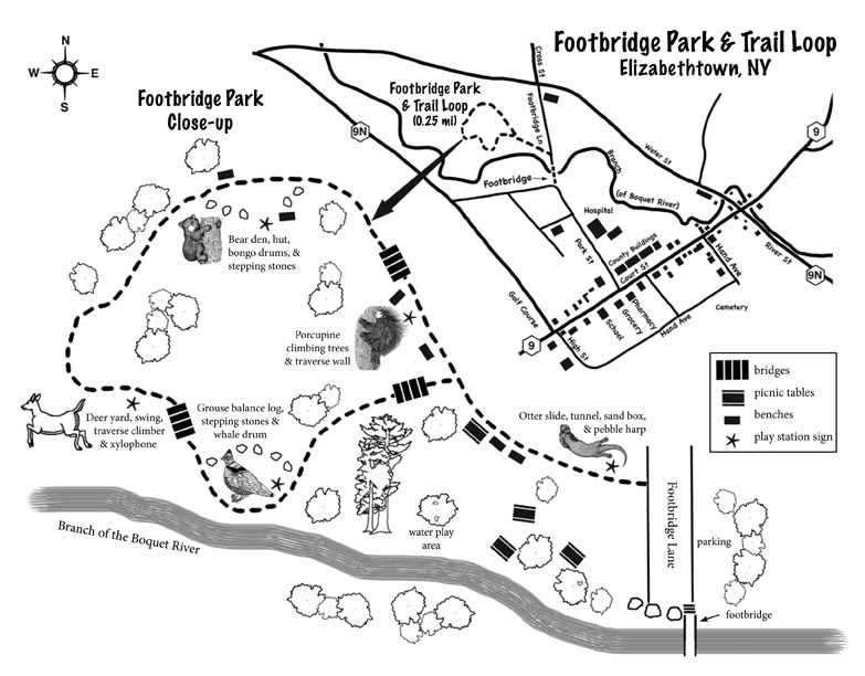
Landmarks - Add some landmarks that can orient the walker, i.e. large rocks, sign post, bridges, large tree, tree stump, etc.
Trail Signs - Sign numbers for interesting sites on the trail can be posted on the map and explained in the guide, even if there are permanent signs on the trail. This lets users know what is there. Species symbols can be placed on the map for trail users to examine on the trail as well. Temporary sites (like a cool bird’s nest) can come and go and be easily added and deleted off a map with colored stakes on the trail. This gives flexibility and added excitement to a trail experience.
The Key - A good key will make your nature trail map more readable. Have it show symbols for the trail, water, wetland, forest and field is essential. Buildings and roads on site should also be identified. Use a dotted or slashed line to note the trail. Streams can be a squiggling line and ponds and lakes a wavy edged shaped (circle, oval etc.) These are universally recognized symbols. The symbols for plants though can be what you wish to make them. On the next page, find 16 pre-made symbols for common trees that you can copy and use in your guide. You can add on the dozens more you will find.
Example Map - Below is a simplified example of a nature trail map with several of the aspects offered above and a good key. This map is not to scale but would work for basic trail needs.
When you research information you must cite the reference. Citing for websites is different from citing from books, magazines and periodicals. The style of citing shown here is from the MLA Style Citations (Modern Language Association).
When citing a WEBSITE the general format is as follows.
Author Last Name, First Name(s). "Title: Subtitle of Part of Web Page, if appropriate." Title: Subtitle: Section of Page if appropriate. Sponsoring/Publishing Agency, If Given. Additional significant descriptive information. Date of Electronic Publication or other Date, such as Last Updated. Day Month Year of access < URL >.
Amsel, Sheri. "Making a Nature Trail Map" Exploring Nature Educational Resource ©2005-2024. December 13, 2024
< http://www.exploringnature.org/db/view/Making-a-Nature-Trail-Map >