_________________________________________________________________________________________________________________________________________________________
Disciplinary Core Ideas
ESS2.A: Earth Materials and Systems
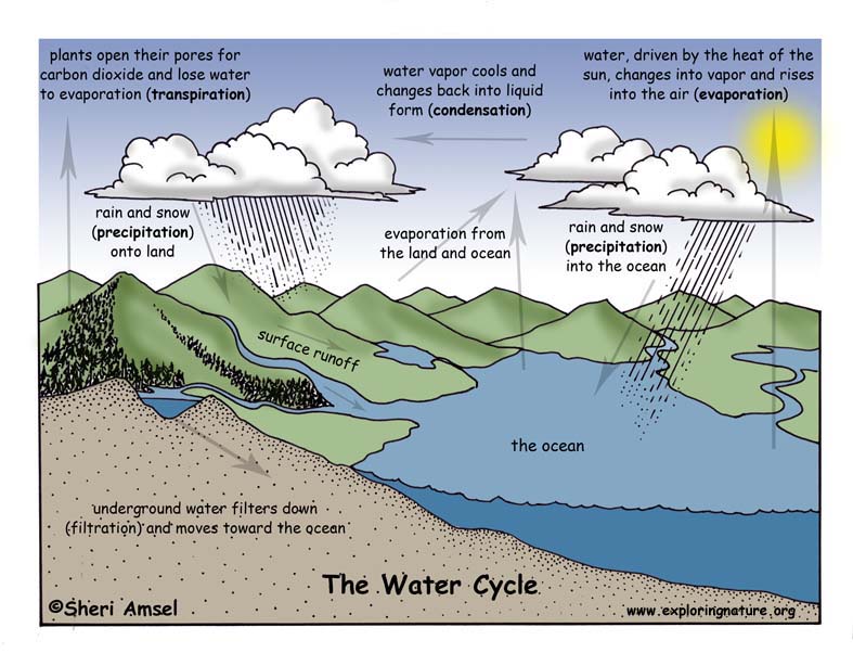
• Rainfall helps to shape the land and affects the types of living things found in a region. Water, ice, wind, living organisms, and gravity break rocks, soils, and sediments into smaller particles and move them around. (4-ESS2-1)
ESS2.B: Plate Tectonics and Large-Scale System Interactions
• The locations of mountain ranges, deep ocean trenches, ocean floor structures, earthquakes, and volcanoes occur in patterns. Most earthquakes and volcanoes occur in bands that are often along the boundaries between continents and oceans. Major mountain chains form inside continents or near their edges. Maps can help locate the different land and water features areas of Earth. (4-ESS2-2)
ESS2.E: Biogeology
• Living things affect the physical characteristics of their regions. (4-ESS2-1)
Performance Expectations Students who demonstrate understanding can:
4-ESS2-1. Make observations and/or measurements to provide evidence of the effects of weathering or the rate of erosion by water, ice, wind, or vegetation. [Clarification Statement: Examples of variables to test could include angle of slope in the downhill movement of water, amount of vegetation, speed of wind, relative rate of deposition, cycles of freezing and thawing of water, cycles of heating and cooling, and volume of water flow.] [Assessment Boundary: Assessment is limited to a single form of weathering or erosion.]
4-ESS2-2. Analyze and interpret data from maps to describe patterns of Earth’s features. [Clarification Statement: Maps can include topographic maps of Earth’s land and ocean floor, as well as maps of the locations of mountains, continental boundaries, volcanoes, and earthquakes.]
_________________________________________________________________________________________________________________________________________________________
Use the Template and Resource Links to Fulfill NGSS
l. Goals:
Essential Questions:
NGSS Note: Think, question, entertain ideas.
ll. Introductory Activities to Assess Prior Knowledge
A. Simple Activities - that assess students’ understanding of the effect of rainfall on the land and living things in a region.
1. Have students find a picture online of land (and living things) that have been affected by rainfall and explain them to the class (i.e. Grand Canyon, erosion, flood devastation).
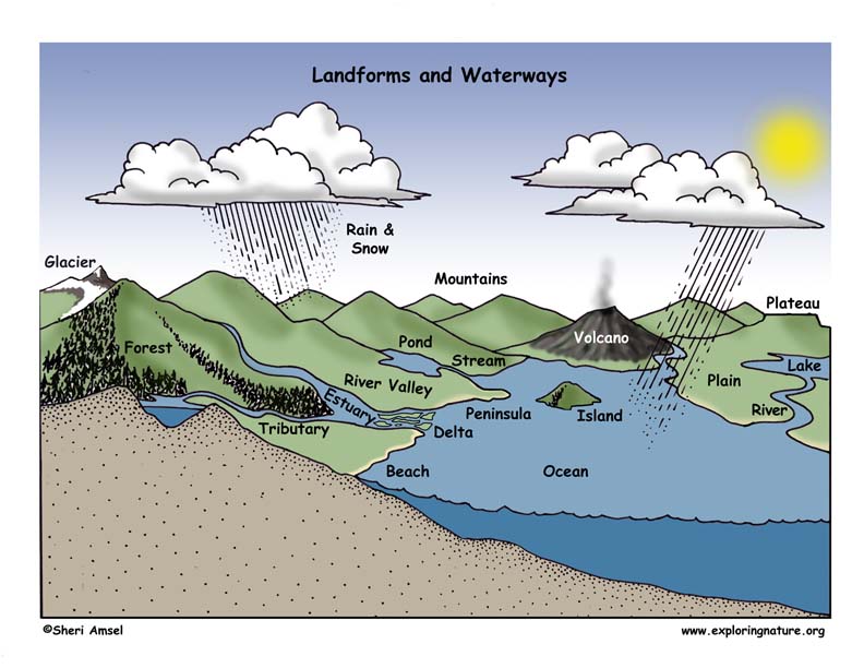
2. Have students draw a map of their state and the waterways and other interesting feature found there.
Question: What are some ways that living things affect the physical characteristics of their regions?
1. Break students down into groups of 3-4.
2. Ask students to come up with several examples of living things affectinf the physical characteristics of their region, i.e. clear-cut forest, terraced rice paddies, etc.
3. Discuss
lll. New Knowledge - Text
A. Read about the effect of rainfall on land.
Rock Identification, the Rock Cycle and Assessment
The Dirt on Dirt -- Why is Soil Important?
Rocks, Erosion and Soil Science ActivitiesAsk students to look at the model of mountain formation and explain how it illustrates the concepts being discussed in this unit.
lV. Experiments, Activities, Model-making (Critical Thinking)
Inquiry related to Earth's waterways and erosion:
V. Summarize Knowledge - Enduring Understandings
Vl. Next Generation of Science Standards (NGSS) - Grade 4
Disciplinary Core Ideas
ESS2.A: Earth Materials and Systems
• Rainfall helps to shape the land and affects the types of living things found in a region. Water, ice, wind, living organisms, and gravity break rocks, soils, and sediments into smaller particles and move them around. (4-ESS2-1)
ESS2.B: Plate Tectonics and Large-Scale System Interactions
• The locations of mountain ranges, deep ocean trenches, ocean floor structures, earthquakes, and volcanoes occur in patterns. Most earthquakes and volcanoes occur in bands that are often along the boundaries between continents and oceans. Major mountain chains form inside continents or near their edges. Maps can help locate the different land and water features areas of Earth. (4-ESS2-2)
ESS2.E: Biogeology
• Living things affect the physical characteristics of their regions. (4-ESS2-1)
Science and Engineering Practices (NGSS)
Planning and Carrying Out Investigations
Planning and carrying out investigations to answer questions or test solutions to problems in 3–5 builds on K–2 experiences and progresses to include investigations that control variables and provide evidence to support explanations or design solutions.
• Make observations and/or measurements to produce data to serve as the basis for evidence for an explanation of a phenomenon. (4-ESS2-1)
Analyzing and Interpreting Data
Analyzing data in 3–5 builds on K–2 experiences and progresses to introducing quantitative approaches to collecting data and conducting multiple trials of qualitative observations. When possible and feasible, digital tools should be used.
• Analyze and interpret data to make sense of phenomena using logical reasoning. (4-ESS2-2)
Crosscutting Concepts
Patterns
• Patterns can be used as evidence to support an explanation. (4-ESS2-2)
Cause and Effect
• Cause and effect relationships are routinely identified, tested, and used to explain change. (4-ESS2-1)
Performance Expectations
Students who demonstrate understanding can:
4-ESS2-1. Make observations and/or measurements to provide evidence of the effects of weathering or the rate of erosion by water, ice, wind, or vegetation. [Clarification Statement: Examples of variables to test could include angle of slope in the downhill movement of water, amount of vegetation, speed of wind, relative rate of deposition, cycles of freezing and thawing of water, cycles of heating and cooling, and volume of water flow.] [Assessment Boundary: Assessment is limited to a single form of weathering or erosion.]
4-ESS2-2. Analyze and interpret data from maps to describe patterns of Earth’s features. [Clarification Statement: Maps can include topographic maps of Earth’s land and ocean floor, as well as maps of the locations of mountains, continental boundaries, volcanoes, and earthquakes.]
Common Core State Standards Connections
ELA/Literacy
RI.4.7 Interpret information presented visually, orally, or quantitatively (e.g., in charts, graphs, diagrams, time lines, animations, or interactive elements on Web pages) and explain how the information contributes to an understanding of the text in which it appears. (4-ESS2-2)
W.4.7 Interpret information presented visually, orally, or quantitatively (e.g., in charts, graphs, diagrams, time lines, animations, or interactive elements on Web pages) and explain how the information contributes to an understanding of the text in which it appears. (4-ESS2-2)
W.4.8 Recall relevant information from experiences or gather relevant information from print and digital sources; take notes and categorize information, and provide a list of sources. (4-ESS2-1)
Mathematics
MP.2 Reason abstractly and quantitatively. (4-ESS2-1)
MP.4 Model with mathematics. (4-ESS2-1)
MP.5 Use appropriate tools strategically. (4-ESS2-1)
4.MD.A.1 Know relative sizes of measurement units within one system of units including km, m, cm; kg, g; lb, oz.; l, ml; hr, min, sec. Within a single system of measurement, express measurements in a larger unit in terms of a smaller unit. Record measurement equivalents in a two-column table. (4-ESS2-1)
4.MD.A.2 Use the four operations to solve word problems involving distances, intervals of time, liquid volumes, masses of objects, and money, including problems involving simple fractions or decimals, and problems that require expressing measurements given in a larger unit in terms of a smaller unit. Represent measurement quantities using diagrams such as number line diagrams that feature a measurement scale. (4-ESS2-1),(4-ESS2-2)
Articulation of DCIs across grade-levels:
2.ESS1.C (4-ESS2-1); 2.ESS2.A (4-ESS2-1); 2.ESS2.B (4-ESS2-2); 2.ESS2.C (4-ESS2-2); 5.ESS2.A (4-ESS2-1); 5.ESS2.C (4-ESS2-2); MS.ESS1.C (4-ESS2-2); MS.ESS2.A (4-ESS2-2); MS.ESS2.B (4-ESS2-2)
When you research information you must cite the reference. Citing for websites is different from citing from books, magazines and periodicals. The style of citing shown here is from the MLA Style Citations (Modern Language Association).
When citing a WEBSITE the general format is as follows.
Author Last Name, First Name(s). "Title: Subtitle of Part of Web Page, if appropriate." Title: Subtitle: Section of Page if appropriate. Sponsoring/Publishing Agency, If Given. Additional significant descriptive information. Date of Electronic Publication or other Date, such as Last Updated. Day Month Year of access < URL >.
Amsel, Sheri. "Grade 4 - 4-ESS2 Earth’s Systems" Exploring Nature Educational Resource ©2005-2024. April 4, 2024
< http://www.exploringnature.org/db/view/1958 >